|
|
|
|
The Kona area of the island of Hawaii is a huge triange, extending from Kukio Bay just south of Waikoloa Village Road, inland to the summit of Mauna Loa, down to Manuka Bay just north of the Manuka State Park, encompassing the districts of South Kona and North Kona. Kona means "Leeward" in Hawaiian. The leeward side of Hawaii island is out of the path of the trade winds that blow from the northeast to the southwest. The trade winds bring rain and humid air to the windward side of the island while the leeward side has sunny days with less rain.
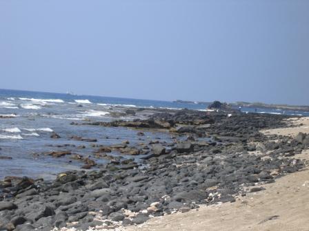
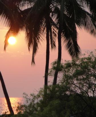
The beaches of Kona are lava rocks with white sand patches. The ocean is turquoise blue under the warm sunlight and the sunsets are spectacular.
Kona has numerous parks to preserve and protect the Kona beaches and ancient Hawaiian culture. Kona Area Libraries Kailua-Kona Public Library Holualoa Public Library Kealakekua Public Library Police Stations Kealakehe Police Station - next to the transfer station Kailua Village Keauhou Captain Cook Public Schools Kealakehe Elementary/Intermediate/High Holualoa Elementary Kahakai Elementary Konawaena Elementory/Middle/High Honaumau Elementary/Intermediate Hookena Elementary/Intermediate Federal Census Designated Areas in Kona Kalaoa Kailua-Kona (96740,96745) Holualoa (96725) Honalo Kahaluu-Keauhou Kealakekua (96750) Captain Cook (96704) Honaunau-Napoopoo County Population 2010 Projections North Kona 34,024 (489 sq miles) South Kona 11,414 (335.4 sq miles) Total Hawaii County 176,938 Copyright 2010 |
| Back to Home |
| About Kona Area |
| Kona Beach Maps |
| Kona Parks |
| County Resources |
| Island Volcano Watch |
| Island Environ Monitor |
| Island Web CAMs |
| Kona Web Links |